
A dusty plain just revealed a hidden code, and the key isn’t a shovel. In Peru’s coastal desert, researchers mapped hundreds of ancient shapes in record time, changing how we read a world treasure. With Artificial Intelligence, the survey moved faster, yet stayed rigorous, because humans still checked every clue. The result reframes mystery as method. It also proves that scale, when paired with careful fieldwork, can expose design, intention, and faith without breaking the spell that keeps Nazca compelling.
Nazca Lines: scope, dating, and what was found
In six months, a Yamagata University–IBM team doubled known figures at a UNESCO World Heritage Site, adding 303 geoglyphs and publishing the advance in PNAS. Guided by Artificial Intelligence, the group worked quickly yet kept context. Lead archaeologist Masato Sakai confirmed the pace and the care behind each verification.
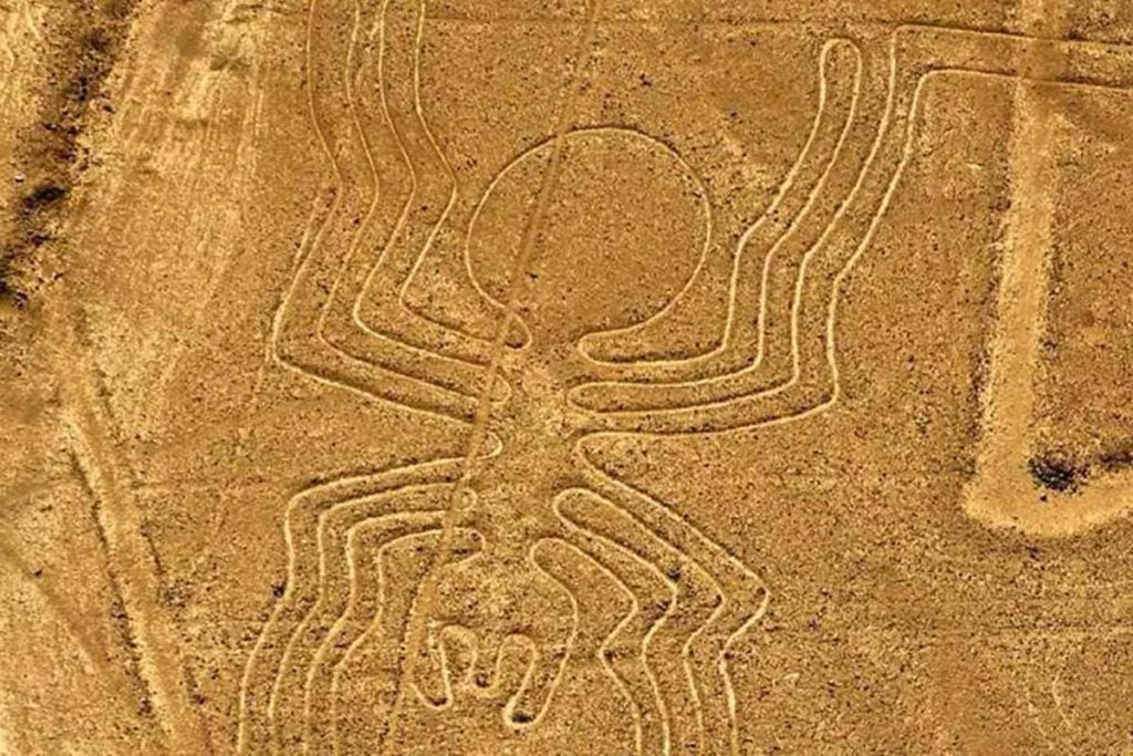
The designs stretch across the desert floor and date roughly from 200 BC to 650 AD. They include stylized felines, birds, fish, plants, and geometric motifs. Many extend for hundreds of meters yet hold striking symmetry. The desert’s scale hid them for centuries, and traditional mapping could not keep up.
Earlier methods—ground surveys, aerial photos, hand-drawn plans—built the foundation. Still, fine lines vanished in glare and dust. Subtle geometry escaped notice, even from planes. The new survey expanded coverage, then rechecked on foot. That cycle—find, confirm, record—protected accuracy while respecting the site’s fragile surface.
How Artificial Intelligence exposed faint lines at massive scale
For more than a century, specialists relied on cameras, compasses, and patience. Now, models trained on thousands of labeled images flag shapes the eye misses. Within the workstream, Artificial Intelligence acts like a tireless scout, pointing to places where lines bend into deliberate forms.
Algorithms sifted terabytes of satellite and drone imagery, balancing recall with precision. The system proposed candidates; teams prioritized the strongest signals. As Sakai noted, speed came from the model, while confidence came from people. Photogrammetry and geospatial tools then turned raw detections into clean, measurable plans.
Each candidate faced ground-truthing. Crews walked the terrain, checked angles, and ruled out tire tracks or drainage. They logged false positives to retrain the model and reduce noise. Because the desert is alive with marks, careful thresholds mattered. That feedback loop turned fast guesses into documented features.
Ritual pathways, sacred journeys, and a planned landscape
The new figures deepen debates on purpose while narrowing wild theories. Many geoglyphs likely guided ritual movement. As processions traced lines, participants engaged gods and landscape together. Inside that choreography, Artificial Intelligence helps restore routes, not replace meaning, because interpretation still lives in context.
Some shapes could mark territory or seasons; others might focus attention rather than measure stars. Symmetry at large scale shows advanced geometry and spatial planning. Builders aligned long edges, balanced curves, and preserved proportions across uneven ground. Such control hints at daily practice, not isolated bursts of inspiration.
Maria Reiche’s patient mapping foreshadowed this integrated view. Orientation, scale, and location make sense as parts of a designed field. Newly found figures sit where paths, sightlines, and slopes interact. Seen this way, the lines compose a landscape instrument—human feet supplied rhythm; wind and sun gave voice.
Where Artificial Intelligence is reshaping digs far beyond Nazca
This leap is not isolated. Across Europe, models locate burial mounds under crops, while lidar reveals settlements beneath forests. In deep water, pattern recognition pinpoints shipwreck shadows. With Artificial Intelligence inside survey stacks, teams cover more ground, compare seasons, and spot change before erosion erases history.
At Saruq Al Hadid in the United Arab Emirates, analysts mapped artifact patterns from satellite data to steer trenches. Pairing remote sensing with photogrammetry created quick, testable hypotheses. That triage saves money and protects layers. Crews dig where evidence converges, so each square meter yields more learning per hour.
Researchers such as João Fonte at ERA Arqueologia call it a step-change. Work that once took years now takes days, because automation handles repetition. Yet speed is useful only when decisions stay careful. Clear protocols, clean metadata, and transparent thresholds keep finds trustworthy and easy to revisit.
Why human judgment still anchors every discovery
Archaeologists warn that models can be wrong with style. Alexandra Karamitrou at the University of Southampton builds tools while stressing limits. Sand, shadows, and tracks confuse detectors. Field teams must confirm, photograph, and log context. Inside that routine, Artificial Intelligence remains assistant, not author, of the record.
Verification protects meaning. Teams check stratigraphy, notes, and GPS, then frame each figure within the wider network. They document edges, crossings, and wear. Those details decide whether a line is ritual path, maintenance trace, or modern scar. Good science preserves options until the ground speaks clearly.
As algorithms improve, so does the chance to save sites at risk. Wind, vehicles, and looting erase marks faster than before. Early alerts help officials act while evidence survives. At Nazca, the expanding map preserves memory from 1,500 years ago and strengthens the case for careful stewardship.
What this breakthrough means for heritage, science, and memory
Speed met patience, and both won. The Peruvian desert now reads less like rumor and more like plan, because teams fused model scale with human sense. With Artificial Intelligence, the puzzle grows clearer without losing wonder. Future surveys will move quickly, yet they should keep feet on the ground and meaning in place.