
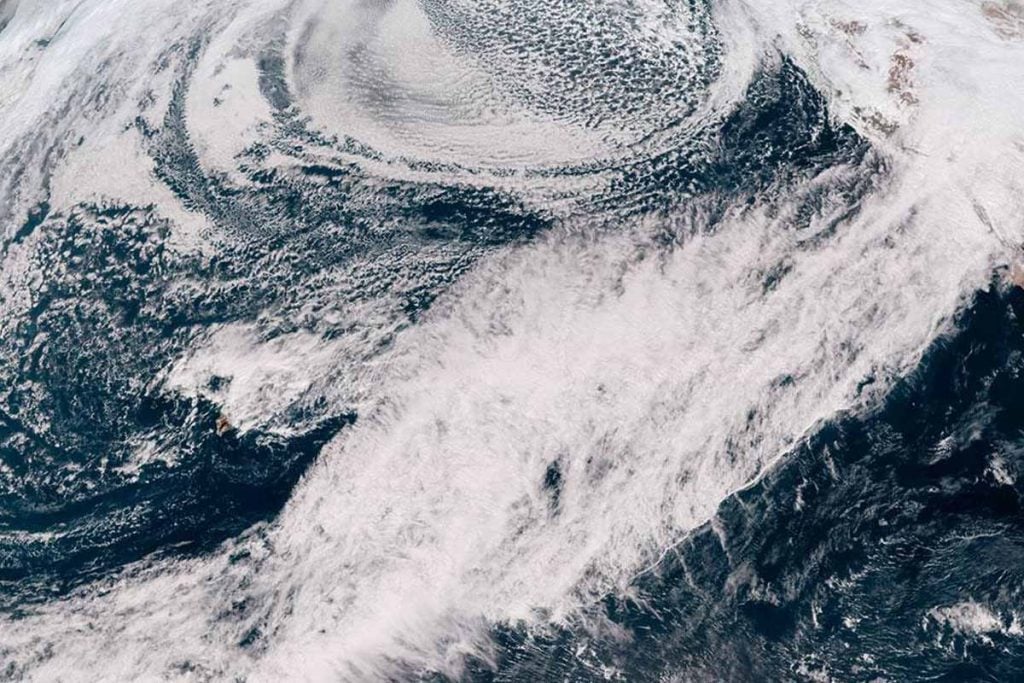
A moisture highway is moving overhead, and its route bends farther from familiar paths. These long, narrow plumes haul immense vapor loads, then unleash intense rain or snow as they slow over land. Because atmospheric rivers decide winter peaks, water supply, and flood risk, their migration now forces cities, farms, and mountains to rethink rules, maps, and timing, while the forecast window narrows and the stakes keep rising.
What sky rivers are, why they form, and where hazards begin
They are tight corridors of extreme vapor transport, sometimes carrying more water than the Amazon River. Land friction slows the flow, so vapor condenses into clouds that dump torrents. Terrain, wind, and temperature shape each outcome, which turns similar plumes into very different days.
One strong plume can bury the Sierra Nevada in several feet of snow. Reservoirs refill fast, yet streets and levees strain because runoff spikes. Neighborhoods take the hit when drains clog, soils saturate, and channels fail, while damage spreads across valleys that planned for gentler storms.
Water managers walk a fine line during peak weeks. They must hold enough storage for drought insurance, yet release space for safety. Each decision now weighs a moving target, since atmospheric rivers no longer follow the same tracks, and single events can swing a season.
Jet streams steer atmospheric rivers and redraw seasonal storm belts
Uneven warming nudges the winds that guide storms. The jet streams have edged poleward, and these plumes ride those belts. As the guides migrate, routes shift too, which alters who gets soaked, who goes dry, and when the biggest days arrive each year.
Former rain belts wait longer between events, then face bursts that strike with sharper intensity. Higher latitudes meet storms that used to fade before arrival. River peaks, soil moisture, and flood timing all change, while farm schedules and urban drainage lose the steady cadence planners counted on.
Designs built around stable winter rhythms struggle. Reservoir rules aimed at January surges miss February peaks. Streets sized for lighter storms can fail under new loads. Because atmospheric rivers now set many seasonal records, local managers track jet behavior as closely as daily forecasts.
Data and methods that reveal a poleward migration since 1979
Researchers mapped paths using ERA5 reanalysis from Europe’s medium-range center. Satellites, weather balloons, and ground stations feed that system. The data reach back to 1979, then blend into hour-by-hour fields, which allow scientists to trace corridors where vapor transport climbs far above background.
They tagged those corridors over roughly forty years and compared positions by latitude. The change stands out: storm corridors moved several degrees toward both poles. In familiar terms, the shift roughly spans the distance between Los Angeles and San Francisco, which already reshapes regional water logistics.
The team includes Zhe Li and Qinghua Ding at the University of California, Santa Barbara. Climate models anticipated many warming impacts, not this specific track change. Still, atmospheric rivers show the result on the ground, since shifted routes move storms, while timing compresses local preparation windows.
Drivers, from Pacific sea-surface patterns to uneven warming and wind changes
Evidence points strongly to ocean conditions, especially the tropical eastern Pacific. Variations in sea-surface temperatures appear to set preferred routes. Uneven continental warming alters pressure patterns too, so jet belts drift, which then carry the plumes along new lines that favor higher latitudes.
Based on those signals, the researchers propose the observed shift is not totally due to direct human forcing. Much of the movement likely reflects natural variability across decades. That view fits the records, yet background warming still loads events, because warmer air can hold more moisture per plume.
Colleagues across fields flagged the surprise. Past expectations leaned on greenhouse signals, not ocean-driven re-routing. The blend matters for planning, since multi-year swings can compound or offset longer trends. Managers weigh both frames, while atmospheric rivers keep delivering the biggest rain and snow days of the year.
Why risks rise as atmospheric rivers shift and storms arrive warmer
Many places rely on three or four big plumes each winter for most annual supply. When paths slide north or south, reservoirs fail to fill, and mountain snowpack thins. Towns that rarely saw these plumes can suddenly face intense events, which expose weak drains and outdated flood maps.
Two processes compound risk. Warmer air loads each corridor with more vapor, so bursts grow stronger. Typical routes change as well, which leaves some regions with fewer events that hit harder, while others get more frequent storms. Local histories help less when the map refuses to stay put.
Timing matters greatly. Warmer storms fall as rain instead of snow, which drives immediate flooding. Snow acts like a slow reservoir for spring and summer. Losing snowpack reduces warm-season water, so hydropower dips, irrigation tightens, and wildfire risk rises after peaks pass and fuels dry fast.
Why preparation must change as storm routes keep shifting fast
Communities adapt best when plans match moving risks. Update flood maps, size drains for higher peaks, and add space for water in towns and fields. Use flexible reservoir rules to balance safety and supply. Strengthen alerts that link forecasts to clear local actions. Coordinate agencies so decisions stay fast and transparent. Because atmospheric rivers keep shifting poleward, test infrastructure, revise agreements, and budget for wetter bursts and longer gaps. Preparation costs less than recovery and protects lives, homes, and work.