
A season can look calm, then flip in a heartbeat. The Old Farmer’s Almanac says the story ahead leans mild while keeping a few wild cards ready. Expect shifts that feel manageable, yet plan smart. Because winter still bites, and timing, place, and moisture will decide who sees what.
Setting the stage for winter outlooks
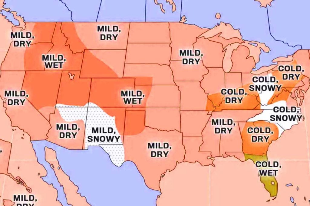
The Almanac frames the coming season as “mostly mild—with pockets of wild” across the continental U.S., with temperatures near normal to slightly milder in many places. Yet winter won’t pass everyone by. Colder-than-average conditions could lock into the Appalachians, the Southeast, Florida, and the Ohio Valley, testing routines and gear.
Published since 1792, it remains the oldest continuously published U.S. periodical. Its team blends solar science, climatology, and meteorology. They read sunspots and broader solar activity, track climate patterns, and study the atmosphere in motion. That mix informs a map where warmth nudges north and east, while select corridors cool.
The broad outlook supports extensive dry periods coast to coast. Nevertheless, exceptions emerge: Florida, the southern High Plains, the Intermountain territory, and the eastern Desert Southwest may experience above-normal precipitation. Residents in those areas should monitor drainage, roofs, and roads, since rain during colder months strains infrastructure.
How the forecast is built and why it varies
The Almanac weighs solar cues, long-term climate signals, and week-to-week weather drivers. That’s why confidence varies by region, and why maps can feel broad. Because winter evolves, local forecasters refine timing and hazards, translating signals into day-to-day decisions and alerts.
A near-normal season still brings cold snaps, wind chills, and black ice. “Mild” can mean shorter freezes or fewer arctic blasts, not balmy streets. The guidance stresses context: a warm-tilted month can still deliver one sharp outbreak. Planning around that swing remains the smart, low-cost hedge for homes.
Drier-than-usual stretches reduce flood risk yet raise fire danger when winds pick up. Where rain runs above average—Florida and the eastern Desert Southwest especially—soil saturation, slick commutes, and urban flooding become the main threats. Knowing which hazard dominates where you live shapes practical, budget-friendly steps.
Regional takeaways and how to prepare
Colder anomalies in the Appalachians, the Southeast, Florida, and the Ohio Valley could boost heating demand and strain travel. Meanwhile, many other areas lean near normal. Because winter still tests basics, check insulation, weatherstrip doors, and service heating. Small fixes save fuel and cut surprise costs.
Snowfall likely lands near or below normal for most. Yet heavier snow is favored in the Carolinas, the southern Appalachians, the eastern Ohio Valley, the southern Rockies, and the eastern Desert Southwest. Drivers there should refresh tire tread, stash traction aids, and map alternate routes, since one heavy band can stall corridors.
The Almanac reminds readers that “mild” is relative. Layering, waterproof footwear, and reflective outerwear still pay off. Keep a shovel handy where storms usually hit. Stock road kits with blankets, chargers, and sand. Short bursts of severe weather remain the main source of real-world disruption and risk.
Timing, totals, and tracks shaping winter risks
Snow probabilities differ from totals. Many places may sit near or below normal, yet one slow-moving system can tip a season locally. Because storm tracks wiggle, the southern Rockies and segments of the Desert Southwest could spike during one event. That’s why winter plans should include flexibility and backup options.
The precipitation pattern leans drier overall, although Florida, the southern High Plains, the Intermountain region, and the eastern Desert Southwest stand out for more rain. According to The Old Farmer’s Almanac, that contrast underscores the role of regional circulation. Communities should align sandbags, culvert cleaning, and gutter maintenance with those signals.
Heavier snow chances in the Carolinas and along the southern Appalachians suggest brief, high-impact periods. The eastern Ohio Valley also sits in that lane. Residents there can speed recovery by scheduling tree pruning, checking sump pumps, and coordinating neighborhood plow priorities. Fast coordination often matters more than perfect forecasts when storms hit.
A second opinion and what to watch next
The Farmer’s Almanac, a separate publication, sketches a colder picture. It points to the Northern Plains through New England for the coldest outbreaks, with significant snow risks in the :
- Pacific Northwest,
- Great Lakes,
- mid-Atlantic.
It places the most intense shots in mid-January and mid-February, classic winter windows.
It also flags a very early start in some areas, with cold and snow possible as early as September. Those notes don’t erase the Old Farmer’s outlook; they add range and timing nuance. When independent outlooks overlap on windows, people can focus preparedness there without overreacting to every model swing.
Managing editor Sarah Perreault told Newsweek the Almanac pairs wit with practical advice and returns to stores each fall while staying true to itself. New editions release annually, so readers get fresh context as patterns evolve. That cadence helps communities translate long-view guidance into ready steps.
Why a little planning now pays off later
The map may lean mild, yet winter still tests plans, gear, and patience. Use the warmth edge to fix drafts, clean gutters, and schedule service before the busiest weeks. Because the sharpest outbreaks often arrive fast, a ready kit, flexible travel plans, and tuned alerts turn uncertainty into manageable, everyday choices.